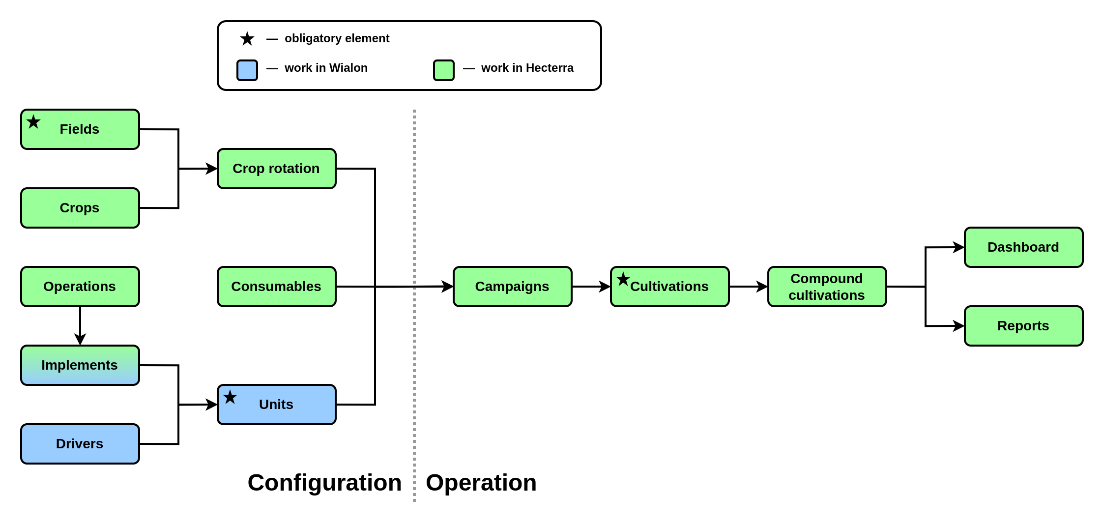
While training partners, the team of trainers noticed that users do not always understand the relationship of elements in our niche applications. This is especially evident if a partner plans to create a proprietary solution based on the application. To solve the problem, we created this diagram. It will give you a general idea of how Hecterra works, although it may not be optimal for learning the application from scratch.

Obligatory elements
Obligatory elements (★) are elements without which the creation or full use of other elements is impossible.
The obligatory elements of Hecterra include fields, units, and cultivations. Other elements are optional, but will make the work with the application more convenient or provide users with new opportunities.
Stages of work
In the diagram, a dotted line distinguishes two stages of work with the application: configuration and operation. It is assumed that the Wialon administrator and/or agronomist configures the elements on the diagram’s left side before the everyday use of Hecterra begins.
Explanation of diagram elements
The Hecterra configuration starts with adding Fields in one of three ways:
- manual creation;
- synchronizing with Wialon (only geofences with the Polygon type are taken into account);
- importing from KML, KMZ or SHP files.
Creating the catalogue of Crops requires specifying the names of cultivated crops and their corresponding colors.
Further, for each field, you can specify a Crop rotation, that is, a list of crops that were cultivated in the past or are being currently cultivated.
You can also add a list of Operations performed in the field to the catalogue. These can be sowing, fertilizing, disk plowing, harrowing, shallow plowing, and so on. For each operation, you can set the Minimum and Maximum speed values, going beyond the range of which will be considered a speed violation (these violations will be highlighted on the map when cultivations are registered).
Hecterra uses Units, Drivers, and Trailers created in the Wialon interface. If a driver is assigned to a unit in the monitoring interface, data about them will be displayed in Hecterra (this statement is also applicable to trailers).
It should be noted that in the Hecterra interface, trailers are called Implements, but they are the same element. For an implement, you can specify the operation it performs, the Working width, and the Deviation relative to the unit center.
In the catalogue, you can also list Consumables, which include Seeds, Fertilizers, and Chemicals.
Here, the configuration stage is completed, and we proceed to the operation stage.
In Hecterra, it is possible to plan the upcoming work using Campaigns. When creating a campaign, you must specify the operation, fields, units involved, and the planned deadline. As you further work in the application, information on the campaign progress will be displayed on the general and daily charts, which allow you to track the expected and actual percent completed to date, as well as the completion of the daily work rate.
The essence of Hecterra's work lies in the manual Cultivation registrar, i.e., the cultivated area. To calculate it, the search algorithm described in the documentation is used. Simply put, the cultivated area is defined as the intersection of the field geofence and the unit’s track, taking into account the working width and the deviation of the assigned implement. Other details of the algorithm can be set in the application settings, allowing you to take into account the state of the work sensor, turning time of the unit, and separate work in the field from driving through it, and so on.
At the end of the working day or other reporting period, a responsible employee must go to the Registrar page and search for potential cultivations by units or campaigns. If all Hecterra elements were previously created and configured, then the driver, implement, operation, crop, and consumables will be listed in the potential cultivation. Moreover, you can specify them manually. For a cultivation, the cultivated area is automatically calculated, as well as overlaps, omissions, area left, and speed limit violations, which are also displayed on the map. If the calculation is correct, an employee can approve the cultivation, and if the calculation is incorrect — decline it or make changes to the cultivation properties and repeat the calculation.
If the same field was cultivated by several units simultaneously or by one unit over several days, but this should be reflected in the report as one cultivation, you can combine several cultivations into a Compound cultivation.
Charts with statistics on crops, cultivations, and campaigns are displayed on the Dashboard tab. Viewing detailed information on campaigns is also available on the same-name tab.
To analyze historical data for a certain period, it is convenient to use Reports of different types.
Oleg Zharkovsky,Customer Service Engineer
2022-12-06