

On the Advanced tab of the unit properties, various parameters are set for generating reports, colors for tracks are adjusted, and speed limitations are set.
Required access: View detailed properties — to view parameters for reports, driver's activity source, and messages filtration settings (the first, the second, the third, and the last sections); Edit not mentioned properties — to edit color schemes of the track/sensor (middle sections); Edit trip detector and fuel consumption — to edit report parameters, and driver's activity source; Edit connectivity settings — to edit parameters of messages filtration (last section).
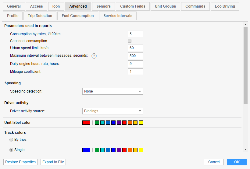
Parameters used in reports
Consumption by rates, l/100 km
In this field, the fuel consumption per 100 km is indicated. To modify it, you need the Edit trip detector and fuel consumption access right towards the unit. Positive digital values can be introduced here. The default value is 0.
Seasonal consumption
Activate this option to set the seasonal calculation of the fuel consumption rate. Specify the fuel consumption per 100 kilometers (default value is 0) and the period (from — to) when this value should be taken into account. To modify this field, the user needs the Edit trip detector and fuel consumption access right towards the unit.
If the Seasonal consumption option is activated, then when a new sensor is created with the help of the math consumption wizard, the Seasonal multiplier option is activated there by default, and the value of the coefficient is counted in accordance with the values specified on the Advanced tab.
Urban speed limit, km/h
This setting is used in the report on trips. If the unit goes with the speed under indicated here, it is considered as urban mileage. If the speed is higher, this mileage is regarded as suburban. This property can be used in the trips reports, statistics, and in the advanced drivers reports.
Maximum interval between messages
Indicate the maximum interval between messages (in seconds). The excess of the specified value is interpreted by the system as a connection loss. This is reflected in the report on connection problems, while calculating intervals in the report on engine hours and during the calculation of fuel consumption by mathematical calculation or by FLS.
Daily engine hours rate
Indicate the daily rate of engine hours to use this value in the engine hours report (when calculating the utilization and useful utilization). The engine hours operation is defined by the corresponding counter.
Mileage Coefficient
The mileage coefficient is useful to compare the detected mileage with the mileage by odometer. The corresponding column can be included in any tabular report containing information about mileage, and in the statistics.
Speeding
In this section, a method for speeding detection can be selected. The selected option defines the order of further actions.
None
The default setting for this method is set to None. It means that speedings are not registered by the system. This option is relevant, for example, for stationary units where such data is not necessary.
Use fixed limit
For the Use fixed limit method the maximum speed limit is specified individually for each unit in the field Fixed speed limit. Upon receiving messages with the speed higher than the indicated one, the speeding is registered by the system. For this method, you can also enter the minimum speeding duration in seconds (1 second by default). The speeding the duration of which is less than the indicated one is not registered by the system as a speeding.
Use limits from roads
The Use limits from roads method is supported only by Gurtam Maps cartographic service.
With the Use limits from roads option, the speeding registration depends on the speed limitations indicated in Gurtam Maps (provided that the road limit is higher than 30 km/h). In other words, the system contains the data on speed limits for the particular road section, and if a unit exceeds this speed limit while moving by this section, the speeding is registered. For this method, you can indicate the tolerance on speeding value. In this case, a speeding is considered to be the movement at a speed that is higher than the sum of the values of speed limit and tolerance on speeding. For example, in some countries exceeding the speed limit by 10 km/h is not a violation, that is why you can indicate 10 km/h tolerance on speeding. Therefore, by a road with the speed limit of 60 km/h, the unit can move with a speed of 70 km/h, and this speed will not be considered a speeding. Moreover, here (the same as for the previous method) the minimum speeding duration can be indicated.
If «0» is indicated in the field Min. speeding time, seconds, the speeding is registered even if there is only one message with speeding, The duration of such interval in the reports is 00:00.
Speedings are registered in the system, and subsequently, you can generate a speedings report. Moreover, during building a track you can enable speeding markers which highlight the corresponding events on the track.
Driver activity
Information on driver activity helps to track whether the driver follows the AETR standards or not. Such information is displayed in the unit or driver tooltips as well as in the extended unit information if the corresponding checkbox is indicated in the user settings.
This section allows choosing the source for determining driver activity. The dropdown list contains 3 items: None, Tachograph, and Bindings. If the None item is chosen, the unit or driver tooltips or the extended unit information do not show the current data on the driver activity. If the Tachograph item is chosen, the information on the activity of a driver bound to this unit is received from the tachograph installed in the vehicle. If the Binding item is chosen (for example, if a vehicle is not equipped with a tachograph), the activity of a driver bound to this unit is determined in the following way:
- Driving status is registered as the driver activity when either trip or stop have been detected for a unit.
- Work status is registered when parking has been detected.
- Rest status is registered upon unbinding a driver from such a unit.
Unit label color
By default, the names of the units and drivers assigned to the units are red on the map. However, you can change this color here and even set various colors for different units.

Track colors
Different colors can be used to show on the map not only the unit itself but also its movements (tracks).
Tracks can be built on the Tracks, Messages, Reports, or Monitoring (the Quick track option) tabs.
Different parts of the track can be colored differently. The settings are made in the Track colors section on the Advanced tab of the unit properties. There are 4 mutually exclusive options: By trips, Single, By speed, By sensor. The option selected in the properties of the unit is also selected for it by default in the tracks panel.
By trips
This option is designed to change the color of the track in accordance with the trips, which are determined by the trip detector.
Single
This option is designed to color the track in one color, which is convenient, for instance when building tracks for unit groups so that they do not visually merge with each other. The color of the track is selected from the palette.
When you sequentially build several tracks for one unit, a different color is used for each of them (taken in order from the palette).

By speed
This option is designed to change the color of the track depending on the speed. To set the values for the speed intervals and indicate their colors, click on the button  . The track color is set for each interval individually. In other words, it is necessary to set an interval, select the color, and click OK. Afterwards, the same procedure should be done for the rest of the intervals. Pay attention to some peculiarities of setting intervals and choosing their color:
- No value in the first field corresponds to -∞, in the second — to +∞.
- When you add an interval that intersects with an existing one and goes beyond its boundaries, the added interval overwrites the existing interval.
- When you add an interval that intersects with an existing one and does not exceed its boundaries, a new interval is inserted inside the existing one. Both intervals, to which the existing one was broken, receive its color.
- You can select a color from the palette or specify it in the HEX format in the field above it.
Upon completion, the intervals of the selected color are displayed on the scale. To edit the interval, click on it with the left mouse button, make the changes and click OK. To reset the settings to their default state, click on the button  to the right of the scale.

By sensor
This option is designed to change the color of the track depending on the readings of a sensor. Select a sensor from the dropdown list (the list is formed on the basis of all the sensors created for a unit). For each created sensor, you can set the interval values and pick their colors. Therefore, when this option is activated, the colors indicated on the interval scale in the properties of the selected sensor are used to draw the track.

Usage of sensor colors
In this section there are three dropdown lists that allow selecting the sensors, the colors of which should be used for:
- showing sensor state in the list of units on the Monitoring tab;
- indicating by color the last state of the sensor of the unit on the map;
- showing the battery level of the device in the work list on the Monitoring tab and in its monitoring options menu on the map.
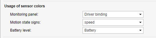
If the unit does not have proper sensors, the options are blocked (inactive).
To configure a sensor that shows the battery level, it is necessary to create a custom sensor with the parameter in which the device sends data about the battery. If these data are not sent in percent, but in volts, it is necessary to fill in the calculation table for the sensor in order to display them correctly in the system.
Messages validity filtration
All the messages are stored in the system without any exception. However, in the case of data spikes, lack of coordinates, etc. such messages may distort the mileage count and various indications in the reports. That is why, it is recommended to enable the filtration of data, in which invalid messages are not taken into account. To adjust the filtration settings, fill in the fields described below. Please note, that the filtration applies only to new messages.
Allow positioning by cellular base stations
Positioning by cellular base stations (LBS detection) is an alternative method of defining unit location. This method involves the use of cellular base stations as reference points for the location detection. Note that the method is not as accurate as the use of GPS, and just allows to receive the approximate location. When this checkbox is enabled, the LBS detection is used only if it is newer than the GPS data.
Skip invalid messages
Some controllers may send a flag about coordinates validity/invalidity in messages. A message with invalid coordinates is marked by the flag of invalidity, and when sending such a message to the server, the current time and the last valid coordinates are given. Wialon will consider this message as a message without position data, and it will be not used when constructing movement tracks, detecting the location in reports, etc. However, if this message contains other parameters (such as sensors), they will be used.
Minimum satellites
If the number of satellites locked is lower, the message is considered to be invalid. The recommended value is at least four.
Maximum HDOP value
HDOP stands for the Horizontal Dilution of Precision. HDOP is an error in the horizontal plane, at which the messages are considered valid. The smaller this parameter, the more accurately the coordinates are determined. If the HDOP value in the message is greater than the specified value, this message is marked as non-valid. Any messages with missing or zero coordinates, also undergo filtering, even if the device did not mark such a message as invalid. A message is recognized as invalid if at least one coordinate (longitude or latitude) is zero.
Maximum speed value
The messages containing speed higher than or equal to the value set here are marked as invalid. The default 0 value does not affect filtering.