Using Geofences
While tracking online
Geofences can be displayed on the map (the ones that have flags in the panel Geofences are shown). That simplifies the visual perception of the map and enriches it. Different regions can be selected by different colors and you can estimate the units’ presence in definite areas. If a geofence is displayed on the map, you can press Ctrl and put the mouse cursor over it to see its tooltip (name, type, list of units inside, etc.). In case of the geofences that have images assigned, the tooltips appear as you just point them with the cursor. If there are 1000 or more geofences, they are automatically grouped on the map. The grouped geofences are displayed by means of a common icon which indicates their number.
In a unit’s tooltip and in its additional information you can see its presence in geofences if the option Presence in geofences is enabled in the user settings.
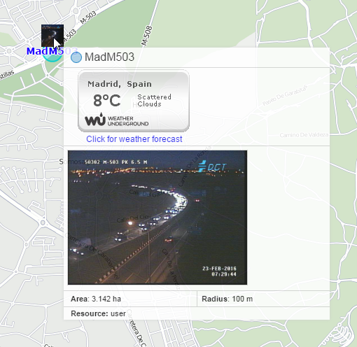
Besides, it is possible to get images from external sources in geofences’ tooltips (webcam videos, photos, rates of exchange, etc.).

Besides, a column with geofences where units are located can be displayed in the Monitoring panel instead of ordinary addresses.
For the Geofences to be displayed on the map you should check if the corresponding layer is active.
In notifications
You can be notified by email, SMS, online or by other means when your unit leaves or enters a geofence. It is also possible to set speed limitations and sensor range for a unit during its presence in a geofence. Besides, entering a geofence or leaving it can be automatically accompanied by action: send a message to the driver, block the engine, change users’ access to this unit, and many others. See Notifications.
In reports
Geofences can be used in reports as addresses (in the Location column) if the Use geofences for addresses flag is enabled in the Advanced settings block of the reports’ template.
Many tables are generated on the basis of geofences. Among them there are the following:
- geofences: visits to geofences (all entries and exits to/from the selected geofence(s) are given together with visit duration, distance travelled within the geofence, average and maximum speed, etc.);
- non-visited Geofences: geofences which were ignored (non-visited) during a period of time or on certain days;
- rides and Unfinished Rides: rides from one geofence to another (convenient to control how cargo is transported in several trips).
Geofences can be also used to filter intervals in reports.
When a report is generated, geofences can be rendered on the map.
In routes
Geofences can be used as check points while configuring routes.