Maps
On the Maps tab, you can configure maps for tracking units. The tab consists of the following sections:
In the Map source and Address format sections, you can select all items at once. To do this, hold down the Ctrl key and select any item in the required section.
Map source
In this section, you can enable the necessary map sources which you can later select in the list of basemaps.
If you enable certain map sources, several types of maps are displayed in the list of basemaps at once. For some types of maps, additional layers are available (for example, traffic layer or maritime navigation).
If only one map source is available to you, this section isn’t displayed.
The use of cartographic services is stipulated by the procedures established by the author or by another right holder of such services. When selecting a cartographic service, you confirm that you acknowledge and accept the full responsibility for its possible misuse.
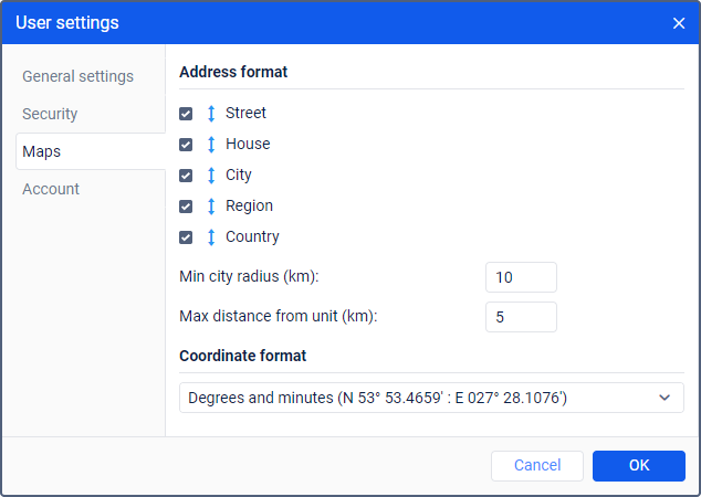
Address format
In this section, you can configure the format in which address information should be displayed in tooltips, tools, messages, etc. The following address elements are available: country, region, city, street, house. You should select at least one element. You can also adjust the order of the elements using the icon  .
.
If units move mainly outside the city, it is advisable to specify the following settings as well:
| Setting | Description |
|---|---|
| Min city radius | Here you should specify the minimum value in kilometers which should be included in the address information as a city radius. If a city is found at the distance specified in the Max distance from unit setting, its address is indicated in the address information. For example, this setting can be useful when address information should contain only major cities. |
| Max distance from unit | Here you should specify the maximum value in kilometers which should be considered the distance from the unit to the city. Thus, if a unit moves along a road and there is a city within the distance specified here, then the name of the road and the distance to the city are indicated in the address of this unit. If several cities are found, the distance to the nearest one is indicated. |
Сoordinate format
In this section, you can select the format in which the cursor coordinates should be displayed in the lower-right corner of the map. There are two options in the dropdown list:
- degrees and minutes;
- degrees.