Measurement System and Conversion
The following measurement systems are supported in Wialon:
- metric;
- U. S.;
- imperial;
- metric with gallons.
The measurement system is set for some macro-objects (units, resources, users, and routes) during their creation. For units and resources, it is the same as in the user settings of the user who creates them; for resources, it is the same as in the settings of the user selected as their creator. You can change the measurement system of existing macro-objects using conversion. Also, users can change their measurement system themselves in the settings.
The measurement system of micro-objects (notifications, geofences, jobs) depends on the resource they belong to. The exceptions are reports, because individual settings are applied to them.
You can also select the measurement system for sensors separately, so that it differs from the measurement system of the unit in the properties of which these sensors are created.
The measurement systems supported in Wialon use the following units of measurement:
| Metric | U.S., imperial | Metric with gallons | |
|---|---|---|---|
Mileage (large values) | Kilometers (km) | Miles (mi) | Kilometers (km) |
Mileage (small values) | Meters (m) | Feet (ft) | Meters (m) |
Speed | Kilometers per hour (km/h) | Miles per hour (mph) | Kilometers per hour (km/h) |
Fuel volume | Litres (l) | Gallons (gal) | Gallons (gal) |
Fuel consumption | Litres per 100 kilometers (l/100 km) | Miles per gallon (mpg) | Kilometers per gallon (kpg) |
Temperature | Degrees Celsius (°С) | Degrees Fahrenheit (°F) | Degrees Celsius (°С) |
Area | Hectares (ha) | Square miles (mi2) or feet (ft2) | Hectares (ha) |
Weight | Tons (t) | Pounds (lbs) | Tons (t) |
Carrying capacity | Tons (t) | Pounds (lbs) | Tons (t) |
Dimensions | Millimeters (mm) | Inches (in) | Millimeters (mm) |
The U. S. and imperial measurement systems use the same units of measurement in all cases, except for calculating fuel consumption. In this case, the units of measurement are converted as follows:
1 U. S. gallon = 0,833 imperial gallons
1 imperial gallon = 1,201 U. S. gallons
Conversion
Conversion is available only in CMS Manager and can be carried out only by the top user.
The conversion is necessary to change the measurement system for already created macro-objects: units, resources, users, and routes. Without conversion, you can only do this for a user, if you have logged in to the system as this user.
To change the measurement system for a macro-object, follow the steps below.
-
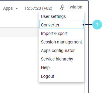
Select Converter in the user menu.

-
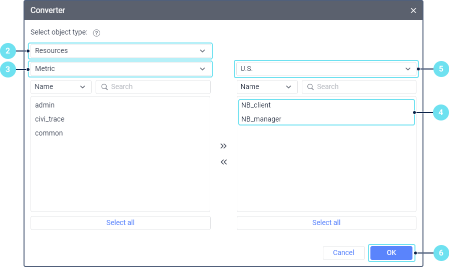
In the drop-down list, select the object type for which you want to carry out the conversion: units, resources, users, or routes. Read more about the conversion particularities of these objects below.

-
Select the original measurement system which you want to change. After you select it, the objects using this system are listed below.
-
Move the objects for which you want to change the measurement system from the left list to the right. For moving the objects, use the icons
 and
and  or a double click on the row. To select several objects, hold down the Ctrl key and click on the required rows. To select all the objects at once, click Select all.
 -
Select the measurement system you want to set for the selected objects.
-
Click ОК to complete the conversion.
As a result, the log shows a record of the completed conversion and the measurement system of the selected objects changes.
Conversion particularities
Below are the conversion particularities of units, resources, users, and routes.
Units
After the conversion, the unit values are recalculated in the following places of the system:
- parameters in the unit properties (trip detection, counters, eco driving criteria, and so on);
- unit tooltip and extended information;
- event registrar;
- fuel consumption settings;
- messages;
- tracks.
The conversion doesn’t affect the unit sensors. To convert them to another measurement system, you should select the required one in the sensor properties manually.
Resources
After the conversion, the following part of the resource content is recalculated:
- geofence properties (area, perimeter, radius, width);
- job settings;
- notification settings.
The conversion is not applied to report templates. You can set the measurement system for each of them individually in the settings. When a report is executed, the measurement system of the resource in which the report is stored and the measure system of the object on which the report is run are not taken into account.
Users
After the conversion is carried out for a user, the measurement system changes:
- for the Min city radius and Max distance from unit options on the Maps tab and the Distance from unit to geofence option on the General settings tab in the user settings;
- for the Distance, Area, Router, Nearest units tools.
In addition, the measurement system set for the user is automatically selected for the units, routes and other users he or she creates (regardless of who is selected as the creator of these objects or in which resource they are created). You can change the measurement system for the user manually at the creation stage.
Routes
After the conversion, the radiuses of check points are recalculated for routes.