Nearest Units
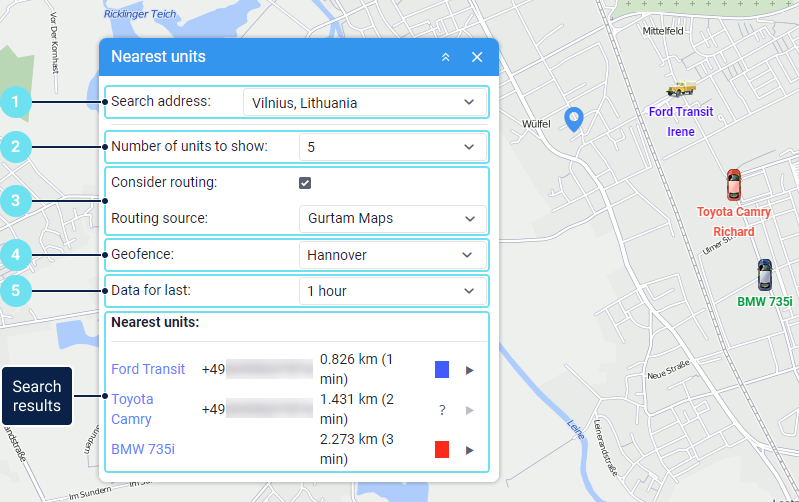
This tool allows you to find those units on the map that according to their latest messages are closest to the specified place. The tool searches only among those units that are added to the work list on the Monitoring tab.
To open the tool, click on the icon  in the tool menu on the left of the map.
To search for units, do the following:

- Specify a location by double-clicking on the map, or start typing an address in the Search address field and select the necessary option from the list. If a city is specified in the user settings, it is shown by default in the address input field.
The addresses are determined only by Gurtam Maps.
- Select the maximum number of the nearest units you want to find: 5, 10 or 20.
- Enable the Consider routing option so that the distance to the unit is calculated taking the roads into account. In addition, if the option is enabled, then the search result shows the time it takes the unit to reach the address you have specified. Gurtam Maps are used as a routing source. The list contains the sources selected in the user settings.
If the option is activated and Gurtam Maps are selected as a routing source, but the distance to the nearest unit is more than 1000 km, then routing is not taken into account.
- If you need to filter units by the geofence in which they are currently located, select the required one in the Geofence field. For example, you can create a geofence around a city and use it to exclude units from other cities.
- In the Data for last field, select the interval of the latest data received from the unit. For example, if you select an interval of 1 hour, the tool takes into account only those units that sent messages within the last hour.
As a result, you get a list of the nearest units with the following information:
| Information type | Comment |
|---|---|
| Unit name | If you click on the unit name, the unit is shown in the centre of the map. |
| Driver's phone number | Displayed if a phone number is specified in the driver properties and the driver is assigned to the unit. |
| Distance from the unit to the specified place | If the Consider routing option is enabled, the distance is calculated taking the roads into account. |
| Travel time | Displayed in brackets next to the distance to the unit if the Consider routing option is enabled. |
| Colour denoting a sensor state | You can see the colour corresponding to the state of the sensor selected in Sensor state option of the unit settings. The colours for the sensor are configured in its properties. The tooltip shows the name of the sensor and the value of its parameter. |
Icon / for sending commands | You can send the commands created on the Commands tab of the unit properties. |