Managing Geofences
To manage geofences, you should have the Create, edit, and delete geofences access right to the resources in which they are stored.
Managing geofences consists in:
- performing actions from the list of geofences: editing, copying, deleting;
- working with geofences on the map;
- viewing information in the geofence tooltips.
List of geofences
By default, geofences are listed in alphabetical order. To switch between the forward and reverse alphabetical order, use the button  /
/ . To quickly find the required geofence, use the dynamic filter or the filter by property (polygons, lines, circles) or by resource.

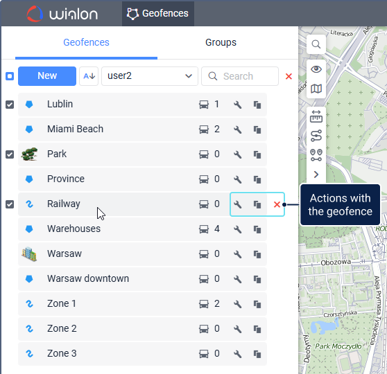
The list of geofences contains icons that show information about geofences and allow you to perform actions with them.
| Icon | Description |
|---|---|
// | The types of geofences: polygon, line, circle. These icons are shown next to the names of the geofences for which no image is selected. |
| The number of units within the geofence. The list of these units is available in the geofence tooltip. If the Presence in geofences option is not enabled in the user settings, question marks are displayed in this column. | |
/ | Open the geofence properties. If you have the Create, edit, and delete geofences access right, you can change the geofence size, type, location on the map, and other properties, except for the resource. If there are more than 5000 points in a geofence, you can’t edit it. |
| Copy the geofence, that is, create a new geofence using the selected one as a template. | |
Delete the geofence. To see the icon, hover over the geofence row. The icon is active if you have the Create, edit, and delete geofences access right. To delete several geofences at once, select them and click on the iconabove their list. |
Geofences on the map
The map displays geofences if:
- they are selected in the list;
- the Geofences layer is enabled;
- the value of the geofence visibility corresponds to the map scale.
To select all the geofences, check the box in the upper row of the list. Click on a geofence name in the list to navigate to this geofence on the map.
On the map, a geofence can be indicated:
- by its name, if the Display names of geofences on map option is enabled in the user settings;
- by its icon, if it is selected in the geofence properties;
- by its shape, if the Display shape on the map option is enabled in the geofence properties (to the left of the geofence color);
- by any combination of these elements.
If the icons overlap due to the geofences being close to one another, they can be replaced by a common icon. For this purpose, the Display overlapping geofences in one icon option should be enabled in the user settings. The common icon has a numeric indicator which shows the number of the grouped geofences. If the number of geofences is 1000 or more, they are grouped by default.
To open the geofence properties, click on the geofence on the map holding down the Ctrl key.
A large number or a large size of geofences can slow down the browser. To avoid this, enable the Render geofences on server option in the user settings.
Geofence tooltip
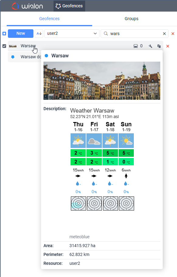
To see the geofence tooltip, point to the name of the geofence in the list or to its icon on the map. You can also point to the geofence itself on the map holding down the Ctrl key.

The tooltip contains the following information:
- geofence type (indicated with an icon);
- geofence name;
- enlarged image;
- description (if specified);
- area (for polygons and circles);
- perimeter (for polygons and circles);
- length (for lines);
- width (for lines);
- name of the resource to which the geofence belongs (if several resources are available);
- list of units within the geofence.
Units of measurement depend on the system of measures of the resource to which the geofence belongs.
If the description contains links to data from other sources, this data is also shown in the tooltip. Below is an example of a code which can be used to display the weather forecast.
<iframe src="https://www.meteoblue.com/en/weather/widget/daily/madrid_espa%c3%b1a_3117735?geoloc=fixed&days=5&tempunit=CELSIUS&windunit=KILOMETER_PER_HOUR&coloured=coloured&pictoicon=1&maxtemperature=1&mintemperature=1&layout=light" frameborder="0" scrolling="NO" allowtransparency="true" sandbox="allow-same-origin allow-scripts allow-popups"></iframe><div><!-- DO NOT REMOVE THIS LINK --><a href="https://www.meteoblue.com/es/tiempo/pronostico/semana/madrid_espa%c3%b1a_3117735?utm_source=weather_widget&utm_medium=linkus&utm_content=daily&utm_campaign=Weather%2BWidget" target="_blank">meteoblue</a></div>


