Configuring a new map service
Who can do it: Service provider
Where: Wialon Platform Studio
To provide a new map or geocoding service to your customers, you must first configure it within Wialon Platform Studio. This process involves selecting a provider, entering your credentials (such as an API key), and customizing the service settings.
You can also create a new map service configuration by copying an existing map service and editing its settings.
To configure a new map service, follow these steps:
-
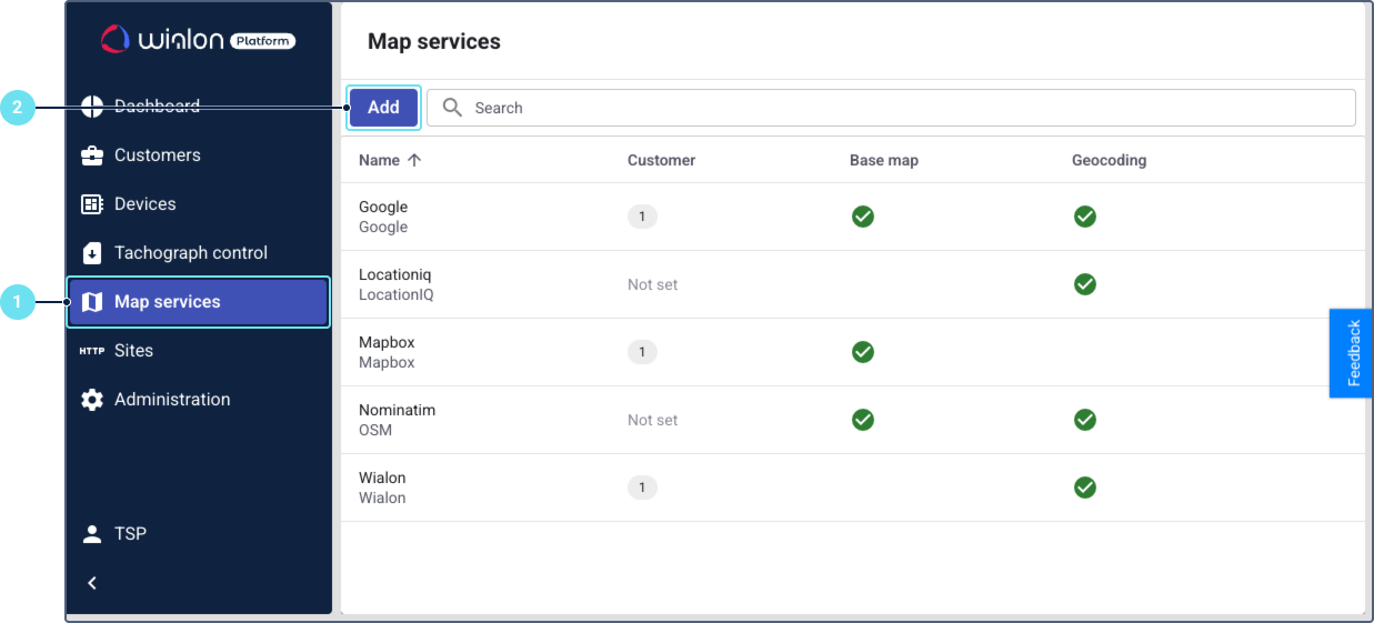
In Wialon Platform Studio, navigate to the Map services page.
-
Click New map service to open the new map service configuration window.
-
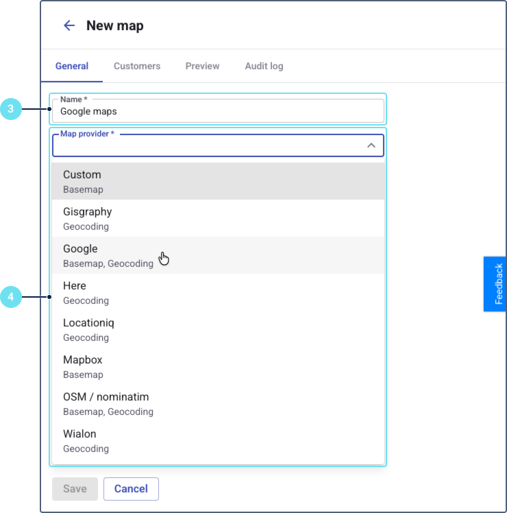
On the General tab, enter the service name. If the service is of the Basemap type and it is enabled for a customer, this name will be visible for the customer in FleetSpace.
-
Select a map provider from the drop-down list. Below the provider name, the available services are displayed: Basemap (map tiles), Geocoding (converting coordinates into addresses), or both. The following providers are supported:
- Custom (basemap)
- Gisgraphy (geocoding)
- Google (basemap, geocoding)
- Here (geocoding)
- Locationiq (geocoding)
- Mapbox (basemap)
- OSM / nominatim (basemap, geocoding)
- Wialon (geocoding)
-
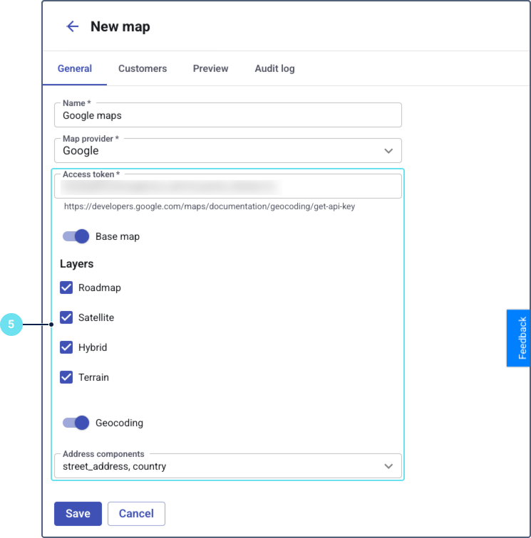
Configure the required parameters such as an access token or API key, visible layers, geocoding, and so on. The settings vary depending on the selected provider. See the Map settings section below for details.
-
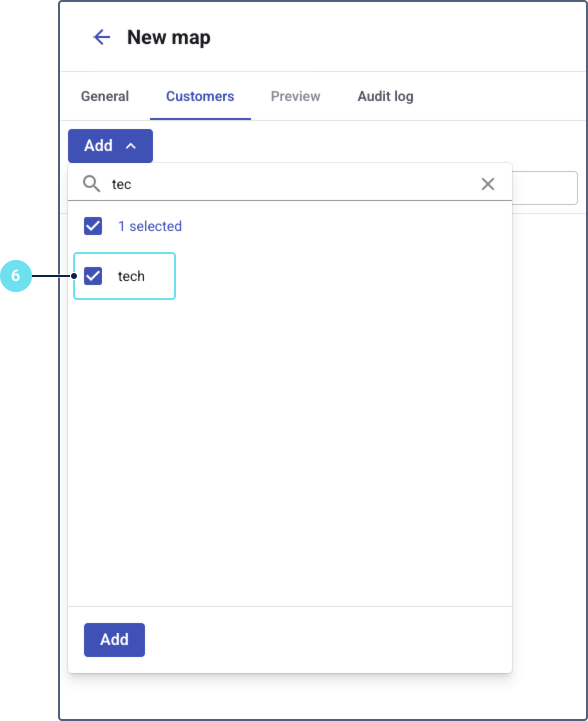
On the Customers tab, assign the map service to one or more customers to make it available in their Wialon Platform FleetSpace interface.
-
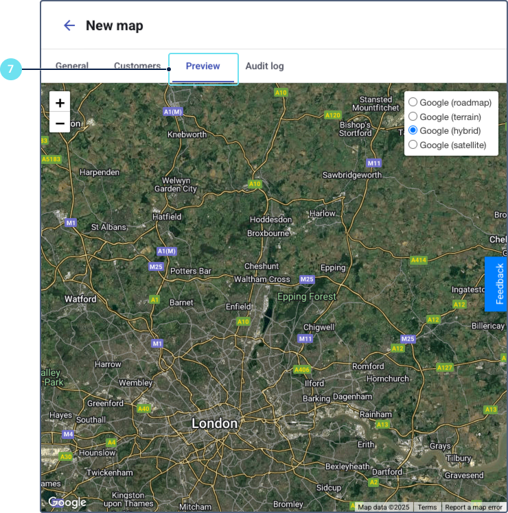
Go to the Preview tab to see how the map will be displayed to the customer. You can pan and zoom to verify that the map tiles and layers load correctly.
-
Return to the General tab and click Save.
Once the map service is configured and assigned, it becomes available to your customers. The geocoding service is applied automatically upon assignment. Basemaps and layers then become available for customers to select within their FleetSpace interface.
Map settings
Below is a summary of configuration options available for supported map providers.
This table shows the settings available for the basemap and geocoding services of the Google provider.
| Setting | Service | Description |
|---|---|---|
| Access token | Basemap, Geocoding | A key used for accessing the map provider API. See how to obtain the API key in Google documentation. |
| Layers | Basemap | Available options are:
You can select several layers. The customer will be able to switch between them in FleetSpace. |
| Language | Geocoding | Sets the language used for addresses. See the code list in Google documentation. |
| Address components | Geocoding | Defines which parts of an address (for example, country, city, street) are used and returned by the geocoding service. You can select multiple components. |
Gisgraphy
This table shows the settings available for the geocoding service of the Gisgraphy provider.
| Setting | Service | Description |
|---|---|---|
| API key | Geocoding | A key used for accessing the Gisgraphy API. See how to obtain the API key on the Gisgraphy site. |
| Base URL | Geocoding | The base URL for the Gisgraphy reverse geocoding service. |
| Address components | Geocoding | Defines which parts of an address (for example, country, city, street) are used and returned by the geocoding service. You can select multiple components. |
Here
This table shows the settings available for the geocoding service of the Here provider.
| Setting | Service | Description |
|---|---|---|
| API key | Geocoding | A key used for accessing the Here API. See how to obtain the API key in the Here documentation. |
| Language | Geocoding | Sets the language used for addresses. |
Locationiq
This table shows what settings are available for the geocoding service of the Locationiq provider.
| Settings | Service | Description |
|---|---|---|
| API key | Geocoding | A key used for accessing the LocationIQ API. See how to get the API key in the LocationIQ documentation. |
| Base URL | Geocoding | The base URL for the LocationIQ reverse geocoding service. You can select the Autocomplete, US or EU Region endpoint from the dropdown list. |
| Language | Geocoding | Sets the language used for addresses. |
| Address components | Geocoding | Defines which parts of an address (for example, country, city, street) are used and returned by the geocoding service. You can select multiple components. |
Mapbox
This table shows the settings available for the basemap service of the Mapbox provider.
| Setting | Service | Description |
|---|---|---|
| Access token | Basemap | A key used for accessing the Mapbox API. See how to obtain the access token in Mapbox documentation. |
| Layers | Basemap | Available options are:
You can select several layers. The customer will be able to switch between them in FleetSpace. |
OSM/nominatim
This table shows the settings available for the basemap and geocoding services of the OSM/nominatim provider.
| Setting | Service | Description |
|---|---|---|
| No additional settings | Basemap | Use the toggle for enabling and disabling the basemap service (tiles). No additional settings are available. |
| URI | Geocoding | The URI for the Nominatim reverse geocoding service endpoint. See Nominatim API reference. |
| Language | Geocoding | Sets the language used for addresses. |
| Headers array | Geocoding | Allows you to add custom HTTP headers (Key and Value) to geocoding requests. |
| Address components | Geocoding | Defines which parts of an address (for example, country, city, street) are used and returned by the reverse geocoding service. You can select multiple components. |
Wialon
Wialon provides only geocoding service without additional settings.
Custom
For the custom map providers, only the basemap (tiles) service is supported. Below are the settings available when configuring basemaps from other providers not included in the supported list.
| Settings | Service | Description |
|---|---|---|
| Type | Basemap | Type of map service. The options are Tile layer and WMS (Web Map Service). A tile layer is a collection of pre-rendered map images, while WMS is a standard for serving dynamically-generated maps. |
| URL | Basemap | The URL template for fetching map tiles or connecting to the WMS server. |
| Overlay | Basemap | A toggle switch that, when enabled, places this map layer on top of other basemaps. You can configure several overlay services. The customer will be able to enable them in FleetSpace. |
| Parameters | Basemap | Allows you to add custom parameters (Key, Value) required by the map service URL. |